Geolocate

Northam topographic map

Click on the map to display elevation.

About this map
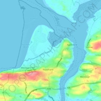
Name: Northam topographic map, elevation, terrain.

Location: Northam, Torridge District, Devon, Devon and Torbay, England, United Kingdom (51.02260 -4.25834 51.07881 -4.18333)

Average elevation: 17 m

Minimum elevation: -1 m

Maximum elevation: 97 m

Other topographic maps

Click on a map to view its topography, its elevation and its terrain.
Diddywells

United Kingdom > England > Devon > Torridge District > Northam

Average elevation: 19 m

Diddywells

United Kingdom > England > Devon > Torridge District > Northam

Average elevation: 19 m

Gear up for your next adventure:

🧢Outdoor Cap - Protective cap for sun and rain during hikes
🧥Packable Rain Jacket - Breathable waterproof layer for unpredictable weather
🔦LED Headlamp - Hands-free lighting for early morning starts or late finishes
🥾Lightweight Hiking Boots - Boots for comfort and mobility on long hikes
🥾Trail Hiking Boots - Supportive boots for rough trails

As an Amazon Associate, this site earns from qualifying purchases at no extra cost to you.