Geolocate

Yateley topographic map

Click on the map to display elevation.

About this map

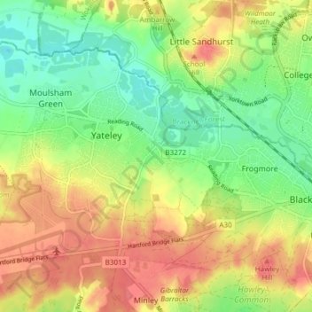
Name: Yateley topographic map, elevation, terrain.

Location: Yateley, Hart, Hampshire, England, United Kingdom (51.32082 -0.85821 51.35334 -0.78323)

Average elevation: 76 m

Minimum elevation: 45 m

Maximum elevation: 107 m

Other topographic maps

Click on a map to view its topography, its elevation and its terrain.

Phoenix Green

United Kingdom > England > Hampshire > Hart

Average elevation: 71 m

Brickkiln Copse

United Kingdom > England > Hampshire > Hart > Hound Green

Average elevation: 61 m

Brookly Stream

United Kingdom > England > Hampshire > Hart > Fleet

Average elevation: 78 m

Beacon Hill

United Kingdom > England > Hampshire > Hart

Average elevation: 139 m

Well

United Kingdom > England > Hampshire > Hart

Average elevation: 138 m

Mattingley

United Kingdom > England > Hampshire > Hart

Average elevation: 65 m

Eversley Cross

United Kingdom > England > Hampshire > Hart

Average elevation: 69 m

Hillside

United Kingdom > England > Hampshire > Hart > Odiham

Average elevation: 98 m

Murrell Green

United Kingdom > England > Hampshire > Hart > Hook

Average elevation: 73 m

Wells Hill

United Kingdom > England > Hampshire > Hart

Average elevation: 122 m

Minley

United Kingdom > England > Hampshire > Hart

Average elevation: 79 m

Gear up for your next adventure:

🥾Mountaineering Boots - Supportive boots for climbing and high-altitude hiking
🔋Solar Power Bank - Keep your GPS and devices charged during long outdoor trips
🔦UV Flashlight - Detect minerals or specific insects in the dark
🧳Compression Sacks - Maximize space in your backpack by shrinking gear
🧭GPS Outdoor Watch - Smart watch for navigation and fitness tracking in nature

As an Amazon Associate, this site earns from qualifying purchases at no extra cost to you.