Geolocate

Hollingworth topographic map

Click on the map to display elevation.

About this map
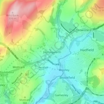
Name: Hollingworth topographic map, elevation, terrain.

Location: Hollingworth, Tameside, Greater Manchester, England, SK14 8LF, United Kingdom (53.44350 -2.01270 53.48350 -1.97270)

Average elevation: 206 m

Minimum elevation: 117 m

Maximum elevation: 399 m

Other topographic maps

Click on a map to view its topography, its elevation and its terrain.

Heyrod

United Kingdom > England > Tameside

Average elevation: 171 m

Mossley

United Kingdom > England > Tameside > Micklehurst

Average elevation: 251 m

River Tame

United Kingdom > England > Tameside

Average elevation: 191 m

Audenshaw

United Kingdom > England > Tameside

Average elevation: 98 m

Hyde Park

United Kingdom > England > Tameside > Hyde

Average elevation: 122 m

Mossley

United Kingdom > England > Tameside > Micklehurst

Average elevation: 226 m

Mossley

United Kingdom > England > Tameside

Average elevation: 226 m

Gear up for your next adventure:

🛶Kayak Dry Bag - Waterproof storage for kayaking adventures
🧣Evaporative Cooling Towel - Beat the heat during intense summer climbs
🔦UV Flashlight - Detect minerals or specific insects in the dark
☕Camping Coffee Maker - Brew fresh coffee anywhere on the topographic map
🧭GPS Outdoor Watch - Smart watch for navigation and fitness tracking in nature

As an Amazon Associate, this site earns from qualifying purchases at no extra cost to you.