Geolocate

Panay topographic map

Click on the map to display elevation.

About this map

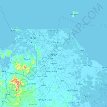
Name: Panay topographic map, elevation, terrain.

Location: Panay, Capiz, Western Visayas, 5801, Philippines (11.48076 122.76476 11.63389 122.98740)

Average elevation: 11 m

Minimum elevation: -3 m

Maximum elevation: 305 m

Other topographic maps

Click on a map to view its topography, its elevation and its terrain.

Nagba

Philippines > Capiz > Cuartero

Average elevation: 23 m

Timpas

Philippines > Capiz > Panitan

Average elevation: 75 m

Roxas

Philippines > Capiz

Average elevation: 10 m

Balat-an

Philippines > Capiz > Mambusao > Balat-an

Average elevation: 41 m

Panay River

Philippines > Capiz > Roxas City > Loctugan

Average elevation: 10 m

Mount Carabao

Philippines > Capiz > Jamindan

Average elevation: 399 m

Gear up for your next adventure:

🥾Lightweight Hiking Boots - Boots for comfort and mobility on long hikes
🧢Hiking Hat - Sun-protective and breathable hats for long treks
📷Outdoor Action Camera - Capture high-elevation views and rugged adventures
💧Hydration Bladder - Hands-free hydration solution for long treks
🧤Thermal Hiking Gloves - Grip-enhanced gloves for cold-weather altitude trekking

As an Amazon Associate, this site earns from qualifying purchases at no extra cost to you.