
Make a donation
Gear up for your next adventure:
As an Amazon Associate, this site earns from qualifying purchases at no extra cost to you.
Abhanpur Tahsil topographic map
Click on the map to display elevation.
Make a donation
Gear up for your next adventure:
As an Amazon Associate, this site earns from qualifying purchases at no extra cost to you.
About this map
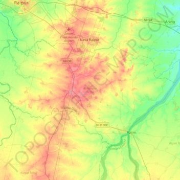
Name: Abhanpur Tahsil topographic map, elevation, terrain.
Location: Abhanpur Tahsil, Raipur District, Chhattisgarh, India (20.94008 81.57617 21.17173 81.97743)
Average elevation: 294 m
Minimum elevation: 265 m
Maximum elevation: 329 m
Make a donation
Gear up for your next adventure:
As an Amazon Associate, this site earns from qualifying purchases at no extra cost to you.
Other topographic maps
Click on a map to view its topography, its elevation and its terrain.
Kawardha
India > Chhattisgarh > Kawardha Tahsil
Kawardha is located at 22°01′N 81°15′E / 22.02°N 81.25°E / 22.02; 81.25. The total area is 798 square miles (2,070 km2). The state consists of hill and forest. It has an average elevation of 353 metres (1,158 ft).
Average elevation: 350 m
Make a donation
Gear up for your next adventure:
As an Amazon Associate, this site earns from qualifying purchases at no extra cost to you.
Sukma
India > Chhattisgarh > Sukma Tahsil
It is located at 18°24′0″N 81°40′0″E / 18.40000°N 81.66667°E / 18.40000; 81.66667 at an elevation of 210 m above MSL.
Average elevation: 219 m
Make a donation
Gear up for your next adventure:
As an Amazon Associate, this site earns from qualifying purchases at no extra cost to you.
Make a donation
Gear up for your next adventure:
As an Amazon Associate, this site earns from qualifying purchases at no extra cost to you.