
Thank you for supporting this site ❤️
Make a donation
Make a donation
Gear up for your next adventure:
As an Amazon Associate, this site earns from qualifying purchases at no extra cost to you.
Marktoberdorf topographic map
Click on the map to display elevation.
Thank you for supporting this site ❤️
Make a donation
Make a donation
Gear up for your next adventure:
As an Amazon Associate, this site earns from qualifying purchases at no extra cost to you.
About this map
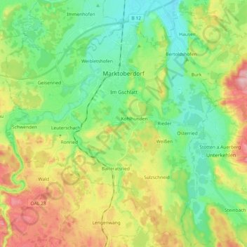
Name: Marktoberdorf topographic map, elevation, terrain.
Location: Marktoberdorf, Landkreis Ostallgäu, Bayern, 87616, Deutschland (47.69431 10.52981 47.80565 10.71268)
Average elevation: 770 m
Minimum elevation: 704 m
Maximum elevation: 888 m
Thank you for supporting this site ❤️
Make a donation
Make a donation
Gear up for your next adventure:
As an Amazon Associate, this site earns from qualifying purchases at no extra cost to you.
Other topographic maps
Click on a map to view its topography, its elevation and its terrain.
Hopfensee
Deutschland > Bayern > Landkreis Ostallgäu > Füssen > Hopfen am See
Average elevation: 799 m