
Make a donation
Gear up for your next adventure:
As an Amazon Associate, this site earns from qualifying purchases at no extra cost to you.
Bayersried topographic map
Click on the map to display elevation.
Make a donation
Gear up for your next adventure:
As an Amazon Associate, this site earns from qualifying purchases at no extra cost to you.
About this map
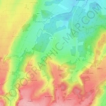
Name: Bayersried topographic map, elevation, terrain.
Average elevation: 731 m
Minimum elevation: 664 m
Maximum elevation: 803 m
Make a donation
Gear up for your next adventure:
As an Amazon Associate, this site earns from qualifying purchases at no extra cost to you.
Other topographic maps
Click on a map to view its topography, its elevation and its terrain.
Aitrang
Deutschland > Bayern > Landkreis Ostallgäu
Die Gemeinde liegt in der Region Allgäu (Bayerisch-Schwaben) zwischen Kaufbeuren (10 km entfernt) und Kempten (in 20 km Entfernung) auf einer Höhe von ca. 740 bis knapp 900 m ü. NHN.
Average elevation: 782 m
Hopfensee
Deutschland > Bayern > Landkreis Ostallgäu > Füssen > Hopfen am See
Average elevation: 799 m
Schwangau
Deutschland > Bayern > Landkreis Ostallgäu
Schwangau liegt im Allgäu, im Süden Bayerns an der Romantischen Straße, die im vier Kilometer entfernten Füssen endet. Die Höhenlage der Gemeinde befindet sich zwischen ca. 770 m ü. NHN (Forggensee) und 2082 m ü. NHN (Hochplatte im Ammergebirge).
Average elevation: 997 m
Make a donation
Gear up for your next adventure:
As an Amazon Associate, this site earns from qualifying purchases at no extra cost to you.