
Beechworth topographic map
Interactive map
Click on the map to display elevation.
About this map
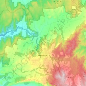
Name: Beechworth topographic map, elevation, terrain.
Location: Beechworth, Shire of Indigo, Victoria, 3747, Australia (-36.42161 146.55797 -36.24622 146.76198)
Average elevation: 484 m
Minimum elevation: 218 m
Maximum elevation: 894 m
Other topographic maps
Click on a map to view its topography, its elevation and its terrain.
Mount Pilot
Australia > Victoria > Beechworth
Mount Pilot, Beechworth, Shire of Indigo, Victoria, Australia
Average elevation: 398 m
Beechworth
Australia > Victoria > Beechworth
Beechworth, Shire of Indigo, Hume, Victoria, 3747, Australia
Average elevation: 533 m