Geolocate

South Hams topographic map

Click on the map to display elevation.

About this map

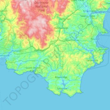
Name: South Hams topographic map, elevation, terrain.

Location: South Hams, Devon, England, United Kingdom (50.20145 -4.19781 50.54262 -3.50742)

Average elevation: 98 m

Minimum elevation: -15 m

Maximum elevation: 525 m

Other topographic maps

Click on a map to view its topography, its elevation and its terrain.

Braunton

United Kingdom > England > Devon > North Devon

Average elevation: 45 m

Lynmouth

United Kingdom > England > Devon > North Devon

Average elevation: 128 m

Torcross

United Kingdom > England > Devon > South Hams > Torcross

Average elevation: 29 m

Burrow

United Kingdom > England > Devon > East Devon > Broadclyst > Burrow

Average elevation: 30 m

Roborough

United Kingdom > England > Devon > South Hams

Average elevation: 123 m

Gear up for your next adventure:

🥾Approach Boots - Comfortable boots for hiking and climbing approaches
🩹Compact First Aid Kit - Pre-packed essentials for common trail injuries
🔋Solar Power Bank - Keep your GPS and devices charged during long outdoor trips
🧦Crew Hiking Socks - Comfortable socks for long-distance hikes
🥾Light Trekking Boots - Supportive boots for multi-day treks

As an Amazon Associate, this site earns from qualifying purchases at no extra cost to you.