Geolocate

Cistierna topographic map

Click on the map to display elevation.

About this map

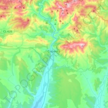
Name: Cistierna topographic map, elevation, terrain.

Location: Cistierna, León, Castile and León, Spain (42.70068 -5.19808 42.89544 -5.04895)

Average elevation: 1,137 m

Minimum elevation: 886 m

Maximum elevation: 1,816 m

Other topographic maps

Click on a map to view its topography, its elevation and its terrain.

Valduga

Spain > Castile and León > Robleda

Average elevation: 809 m

Quintanilla de Somoza

Spain > Castile and León > Luyego

Average elevation: 1,079 m

Gear up for your next adventure:

🥾Hiking Shoes - Durable and comfortable shoes for trail hiking
🥾Hiking Gaiters - Protect legs and shoes from mud, snow, and debris
🔥Emergency Fire Starter - Reliable ignition source for all weather conditions
🧦Merino Wool Socks - Moisture-wicking comfort for long-distance hiking
🥾Lightweight Hiking Shoes - Comfortable shoes for day hikes

As an Amazon Associate, this site earns from qualifying purchases at no extra cost to you.