Geolocate

9th district topographic map

Click on the map to display elevation.

About this map

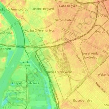
Name: 9th district topographic map, elevation, terrain.

Location: 9th district, Budapest, Central Hungary, Hungary (47.43996 19.05498 47.48975 19.12833)

Average elevation: 112 m

Minimum elevation: 89 m

Maximum elevation: 124 m

Other topographic maps

Click on a map to view its topography, its elevation and its terrain.

Danube

Hungary > Budapest

Average elevation: 114 m

Kis-Sváb-hegy

Hungary > Budapest

Average elevation: 195 m

Gellért Hill

Hungary > Budapest

Average elevation: 126 m

Csúcs-hegy

Hungary > Budapest

Average elevation: 261 m

Gellért Hill

Hungary > Budapest

Average elevation: 126 m

Ziggurat

Hungary > Budapest

Average elevation: 108 m

Tigers

Hungary > Budapest

Average elevation: 111 m

Danube

Hungary > Budapest

Average elevation: 125 m

Gear up for your next adventure:

🕯️Camping Lantern - Illuminates your entire campsite with high-efficiency LEDs
Lightweight Camping Tent - Portable shelter optimized for Canadian backcountry camping
❄️Traction Ice Cleats - Slip-on spikes for icy trails and winter hiking
🥾Trekking Poles - Adjustable trekking poles to reduce knee stress and improve stability
🧤Rechargeable Heated Gloves - Extreme warmth for Canadian winter expeditions

As an Amazon Associate, this site earns from qualifying purchases at no extra cost to you.