
Make a donation
Gear up for your next adventure:
As an Amazon Associate, this site earns from qualifying purchases at no extra cost to you.
Gosberton Clough topographic map
Click on the map to display elevation.
Make a donation
Gear up for your next adventure:
As an Amazon Associate, this site earns from qualifying purchases at no extra cost to you.
About this map
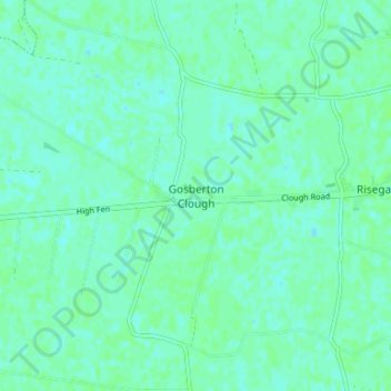
Name: Gosberton Clough topographic map, elevation, terrain.
Average elevation: 3 m
Minimum elevation: 0 m
Maximum elevation: 6 m
Make a donation
Gear up for your next adventure:
As an Amazon Associate, this site earns from qualifying purchases at no extra cost to you.
Other topographic maps
Click on a map to view its topography, its elevation and its terrain.
Deeping St. Nicholas
United Kingdom > England > Lincolnshire > South Holland > Deeping St Nicholas
Average elevation: 3 m
Make a donation
Gear up for your next adventure:
As an Amazon Associate, this site earns from qualifying purchases at no extra cost to you.
Sutton St. Edmund
United Kingdom > England > Lincolnshire > South Holland > Sutton St Edmund
Average elevation: 1 m
Long Sutton
United Kingdom > England > Lincolnshire > South Holland > Long Sutton
Average elevation: 3 m
Make a donation
Gear up for your next adventure:
As an Amazon Associate, this site earns from qualifying purchases at no extra cost to you.
Tydd St. Mary
United Kingdom > England > Lincolnshire > South Holland > Tydd St Mary
Average elevation: 3 m
Make a donation
Gear up for your next adventure:
As an Amazon Associate, this site earns from qualifying purchases at no extra cost to you.
Sutton St. James
United Kingdom > England > Lincolnshire > South Holland > Sutton St James
Average elevation: 2 m
Make a donation
Gear up for your next adventure:
As an Amazon Associate, this site earns from qualifying purchases at no extra cost to you.