Geolocate

San Isidro topographic map

Click on the map to display elevation.

About this map

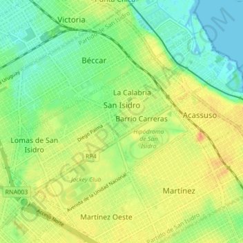
Name: San Isidro topographic map, elevation, terrain.

Location: San Isidro, Partido de San Isidro, Buenos Aires, Argentina (-34.49895 -58.56441 -34.45654 -58.49584)

Average elevation: 17 m

Minimum elevation: -1 m

Maximum elevation: 36 m

Other topographic maps

Click on a map to view its topography, its elevation and its terrain.

Berisso

Argentina > Buenos Aires

Average elevation: 6 m

Emilio V. Bunge

Argentina > Buenos Aires

Average elevation: 126 m

Azul

Argentina > Buenos Aires

Average elevation: 137 m

Grand Bourg

Argentina > Buenos Aires > Grand Bourg > Grand Bourg

Average elevation: 26 m

Gear up for your next adventure:

Camping Coffee Maker - Brew fresh coffee anywhere on the topographic map
💧Filtered Water Bottle - Safe drinking water on the go
🧢Beanie Hat - Keep your head warm in cold weather
📷Outdoor Action Camera - Capture high-elevation views and rugged adventures
🥾Hiking Leggings - Comfortable leggings for outdoor activities

As an Amazon Associate, this site earns from qualifying purchases at no extra cost to you.