Geolocate

Palmou topographic map

Click on the map to display elevation.

About this map

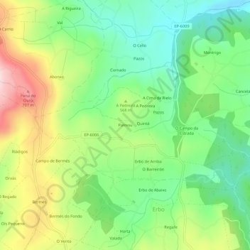
Name: Palmou topographic map, elevation, terrain.

Location: Palmou, Lalín, Deza, Pontevedra, Galicia, 36517, España (42.71039 -8.13965 42.75039 -8.09965)

Average elevation: 547 m

Minimum elevation: 426 m

Maximum elevation: 742 m

Other topographic maps

Click on a map to view its topography, its elevation and its terrain.

Zobra

España > Galicia > Deza > Lalín

Average elevation: 692 m

Busto

España > Galicia > Deza > Lalín

Average elevation: 613 m

Cercio

España > Galicia > Deza > Lalín

Average elevation: 469 m

Rodís

España > Galicia > Deza > Lalín

Average elevation: 431 m

Bendoiro

España > Galicia > Deza > Lalín

Average elevation: 474 m

Gear up for your next adventure:

🧭Orienteering Kit - Tools for map reading and navigation in the wild
🥾Light Trekking Boots - Supportive boots for multi-day treks
🧥Waterproof Hiking Jacket - Protect yourself from rain and wind while hiking
🧥Packable Rain Jacket - Breathable waterproof layer for unpredictable weather
🥾Lightweight Hiking Boots - Boots for comfort and mobility on long hikes

As an Amazon Associate, this site earns from qualifying purchases at no extra cost to you.