
Lakselv topographic map
Click on the map to display elevation.
About this map
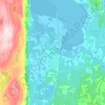
Name: Lakselv topographic map, elevation, terrain.
Location: Lakselv, Porsanger, Finnmark, 9700, Norway (70.01250 24.92066 70.09250 25.00066)
Average elevation: 133 m
Minimum elevation: -4 m
Maximum elevation: 626 m
Other topographic maps
Click on a map to view its topography, its elevation and its terrain.
Alta
The town of Alta and most of the municipality is located just below the 70th latitude and is closer to the North Pole than it is to much of Central Europe and the British Isles. The town is the northernmost settlement of urban significance in the European Economic Area, with municipalities north of Alta being…
Average elevation: 372 m