Geolocate

Lebesby topographic map

Click on the map to display elevation.

About this map

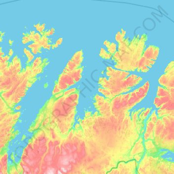
Name: Lebesby topographic map, elevation, terrain.

Location: Lebesby, Finnmark, Norway (69.97312 25.91305 71.35179 27.77429)

Average elevation: 158 m

Minimum elevation: -3 m

Maximum elevation: 1,043 m

Other topographic maps

Click on a map to view its topography, its elevation and its terrain.

Lakselv

Norway > Finnmark

Average elevation: 133 m

Skuvvanvárri - Skoganvarre

Norway > Finnmark

Average elevation: 121 m

Savu

Norway > Finnmark

Average elevation: 385 m

Nalganas Skiferfelt

Norway > Finnmark > Alta

Average elevation: 278 m

North Cape

Norway > Finnmark

Average elevation: 87 m

Deanušaldi - Tana bru

Norway > Finnmark

Average elevation: 90 m

Vardø

Norway > Finnmark

Average elevation: 10 m

Kirkenes

Norway > Finnmark

Average elevation: 63 m

North Cape

Norway > Finnmark

Average elevation: 64 m

Gear up for your next adventure:

🧢Hiking Sun Hat - Wide-brimmed protection for exposed mountain ridges
🪑Insulated Seat Pad - Protect your seat from cold rocks and wet logs
🧥Waterproof Pants - Keep dry during rainy hiking conditions
💧Hydration Pack - Hands-free hydration system for long hikes
🧊Insulated Water Bottle - Keeps drinks cold in summer and prevents freezing in winter

As an Amazon Associate, this site earns from qualifying purchases at no extra cost to you.