
Make a donation
Gear up for your next adventure:
As an Amazon Associate, this site earns from qualifying purchases at no extra cost to you.
East Lake topographic map
Click on the map to display elevation.
Make a donation
Gear up for your next adventure:
As an Amazon Associate, this site earns from qualifying purchases at no extra cost to you.
About this map
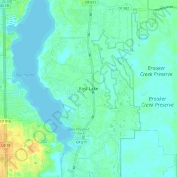
Name: East Lake topographic map, elevation, terrain.
Location: East Lake, Pinellas County, Florida, 34685, United States (28.06837 -82.73685 28.14837 -82.65685)
Average elevation: 7 m
Minimum elevation: -2 m
Maximum elevation: 27 m
Make a donation
Gear up for your next adventure:
As an Amazon Associate, this site earns from qualifying purchases at no extra cost to you.
Other topographic maps
Click on a map to view its topography, its elevation and its terrain.
Make a donation
Gear up for your next adventure:
As an Amazon Associate, this site earns from qualifying purchases at no extra cost to you.
Treasure Island
United States > Florida > Pinellas County
With an elevation of only three feet, the Great Gale of 1848 carved out John's Pass on the island's north end and split off two smaller islands, called the Isle of Palms and Isle of Capri.
Average elevation: 2 m
Make a donation
Gear up for your next adventure:
As an Amazon Associate, this site earns from qualifying purchases at no extra cost to you.
Saint George Lake
United States > Florida > Pinellas County > Palm Harbor > Saint George
Average elevation: 12 m
Make a donation
Gear up for your next adventure:
As an Amazon Associate, this site earns from qualifying purchases at no extra cost to you.