Geolocate

Cotacachi topographic map

Click on the map to display elevation.

About this map

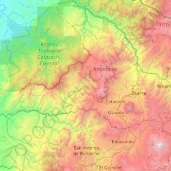
Name: Cotacachi topographic map, elevation, terrain.

Location: Cotacachi, Imbabura, Ecuador (0.20427 -79.27576 0.58683 -78.21516)

Average elevation: 2,044 m

Minimum elevation: 2 m

Maximum elevation: 5,736 m

Other topographic maps

Click on a map to view its topography, its elevation and its terrain.

Lago San Pablo

Ecuador > Imbabura > Otavalo > Otavalo

Average elevation: 2,675 m

Caranqui

Ecuador > Imbabura > Otavalo > Calpaquí

Average elevation: 2,684 m

Montes Quisaya

Ecuador > Imbabura > Cotacachi

Average elevation: 1,492 m

Cadena

Ecuador > Imbabura > Ibarra > La Esperanza

Average elevation: 2,575 m

Nangulví Bajo

Ecuador > Imbabura > Cotacachi > Peñaherrera

Average elevation: 1,651 m

Zuleta

Ecuador > Imbabura > Ibarra > Angochagua

Average elevation: 2,977 m

Santa Theresa

Ecuador > Imbabura > Ibarra > Angochagua

Average elevation: 3,018 m

Gear up for your next adventure:

🧰Multitool Knife - Compact and versatile tool for outdoor use
💧Hydration Bladder - Hands-free hydration solution for long treks
🧢Sun Hat - Wide-brim hat for sun protection
🥾Lightweight Hiking Shoes - Comfortable shoes for day hikes
🔦LED Flashlight - Powerful and long-lasting flashlight for camping and emergencies

As an Amazon Associate, this site earns from qualifying purchases at no extra cost to you.