Geolocate

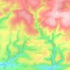
Middle Marwood topographic map

Click on the map to display elevation.

About this map

Name: Middle Marwood topographic map, elevation, terrain.

Location: Middle Marwood, Marwood, North Devon, Devon, Devon and Torbay, England, EX31 4EG, United Kingdom (51.11054 -4.11229 51.15054 -4.07229)

Average elevation: 147 m

Minimum elevation: 46 m

Maximum elevation: 241 m

Other topographic maps

Click on a map to view its topography, its elevation and its terrain.
Marwood

United Kingdom > England > Devon > North Devon > Marwood

Average elevation: 152 m

Gear up for your next adventure:

🔭Outdoor Binoculars - Lightweight binoculars for birdwatching and hiking
👟Trail Running Shoes - Agile footwear for fast-paced topographic exploration
🔋Emergency Crank Radio - Weather alerts and power without needing batteries
🧥Softshell Hiking Jacket - The perfect balance of wind protection and breathability
🚲MTB Frame Bag - Carry tools and maps directly on your bicycle frame

As an Amazon Associate, this site earns from qualifying purchases at no extra cost to you.