Geolocate

Hazelton topographic map

Click on the map to display elevation.

About this map
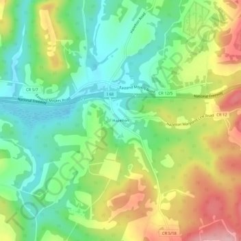
Name: Hazelton topographic map, elevation, terrain.

Location: Hazelton, Preston County, West Virginia, United States (39.63369 -79.55060 39.67369 -79.51060)

Average elevation: 621 m

Minimum elevation: 554 m

Maximum elevation: 722 m

Other topographic maps

Click on a map to view its topography, its elevation and its terrain.
Kingwood

United States > West Virginia > Preston County

Average elevation: 530 m

Masontown

United States > West Virginia > Preston County

Average elevation: 541 m

Tunnelton

United States > West Virginia > Preston County

Average elevation: 596 m

Kingwood

United States > West Virginia > Preston County

Average elevation: 530 m

Masontown

United States > West Virginia > Preston County

Average elevation: 541 m

Newburg

United States > West Virginia > Preston County

Average elevation: 451 m

Kingwood

United States > West Virginia > Preston County

Average elevation: 530 m

Gear up for your next adventure:

🚲MTB Frame Bag - Carry tools and maps directly on your bicycle frame
⛺Tent Footprint - Protect tent floor and increase durability
🛶Kayak Accessories - Essential gear for safe and fun kayaking adventures
🧼Travel Hand Sanitizer - Keep hands clean when water is scarce
🧭GPS Handheld Device - Reliable GPS navigation for outdoor adventures

As an Amazon Associate, this site earns from qualifying purchases at no extra cost to you.