Geolocate

Mottola topographic map

Click on the map to display elevation.

About this map
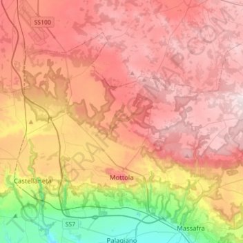
Name: Mottola topographic map, elevation, terrain.

Location: Mottola, Taranto, Apulia, 74017, Italy (40.60374 16.92373 40.76076 17.20330)

Average elevation: 299 m

Minimum elevation: 22 m

Maximum elevation: 500 m

Other topographic maps

Click on a map to view its topography, its elevation and its terrain.
Saturo

Italy > Apulia > Taranto > Leporano

Average elevation: 12 m

Marinara

Italy > Apulia > Taranto > Mottola

Average elevation: 261 m

Gear up for your next adventure:

⛺Camping Groundsheet - Protect your tent from moisture and dirt
🧢Sun Hat - Wide-brim hat for sun protection
🧤Insulated Winter Gloves - Heavy-duty protection for sub-zero Canadian adventures
🧴Outdoor Sunscreen - High SPF protection for high-altitude UV exposure
🥾Trail Hiking Socks - Comfortable socks to prevent blisters and fatigue

As an Amazon Associate, this site earns from qualifying purchases at no extra cost to you.