
Make a donation
Gear up for your next adventure:
As an Amazon Associate, this site earns from qualifying purchases at no extra cost to you.
Alford topographic map
Click on the map to display elevation.
Make a donation
Gear up for your next adventure:
As an Amazon Associate, this site earns from qualifying purchases at no extra cost to you.
About this map
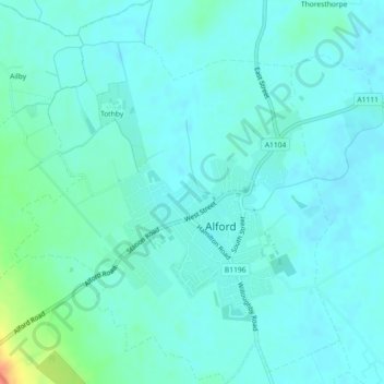
Name: Alford topographic map, elevation, terrain.
Average elevation: 9 m
Minimum elevation: 2 m
Maximum elevation: 33 m
Make a donation
Gear up for your next adventure:
As an Amazon Associate, this site earns from qualifying purchases at no extra cost to you.
Other topographic maps
Click on a map to view its topography, its elevation and its terrain.
Ashby by Partney
United Kingdom > England > Lincolnshire > East Lindsey > Halton Holegate
Average elevation: 20 m
Make a donation
Gear up for your next adventure:
As an Amazon Associate, this site earns from qualifying purchases at no extra cost to you.
Make a donation
Gear up for your next adventure:
As an Amazon Associate, this site earns from qualifying purchases at no extra cost to you.
Make a donation
Gear up for your next adventure:
As an Amazon Associate, this site earns from qualifying purchases at no extra cost to you.
Belleau Bridge
United Kingdom > England > Lincolnshire > East Lindsey > Aby > Belleau
Average elevation: 30 m
Make a donation
Gear up for your next adventure:
As an Amazon Associate, this site earns from qualifying purchases at no extra cost to you.
Louth Navigation
United Kingdom > England > Lincolnshire > East Lindsey > Alvingham
Average elevation: 8 m
Make a donation
Gear up for your next adventure:
As an Amazon Associate, this site earns from qualifying purchases at no extra cost to you.
Bowser's Corner
United Kingdom > England > Lincolnshire > East Lindsey > New Leake
Average elevation: 1 m
Make a donation
Gear up for your next adventure:
As an Amazon Associate, this site earns from qualifying purchases at no extra cost to you.
Make a donation
Gear up for your next adventure:
As an Amazon Associate, this site earns from qualifying purchases at no extra cost to you.
Make a donation
Gear up for your next adventure:
As an Amazon Associate, this site earns from qualifying purchases at no extra cost to you.
Halton Fenside
United Kingdom > England > Lincolnshire > East Lindsey > Little Steeping
Average elevation: 8 m
Make a donation
Gear up for your next adventure:
As an Amazon Associate, this site earns from qualifying purchases at no extra cost to you.
Wainfleet Haven
United Kingdom > England > Lincolnshire > East Lindsey > Wainfleet Clough
Average elevation: 3 m
Make a donation
Gear up for your next adventure:
As an Amazon Associate, this site earns from qualifying purchases at no extra cost to you.
The Lymn
United Kingdom > England > Lincolnshire > East Lindsey > Thorpe St. Peter
Average elevation: 2 m
Make a donation
Gear up for your next adventure:
As an Amazon Associate, this site earns from qualifying purchases at no extra cost to you.
Acre Bridge
United Kingdom > England > Lincolnshire > East Lindsey > Conisholme
Average elevation: 2 m
Make a donation
Gear up for your next adventure:
As an Amazon Associate, this site earns from qualifying purchases at no extra cost to you.
Kirkby Fenside
United Kingdom > England > Lincolnshire > East Lindsey > East Kirkby
Average elevation: 12 m
Make a donation
Gear up for your next adventure:
As an Amazon Associate, this site earns from qualifying purchases at no extra cost to you.
Bag Enderby
United Kingdom > England > Lincolnshire > East Lindsey > Bag Enderby
Average elevation: 56 m
Make a donation
Gear up for your next adventure:
As an Amazon Associate, this site earns from qualifying purchases at no extra cost to you.
Sutton le Marsh
United Kingdom > England > Lincolnshire > East Lindsey > Sutton-on-Sea > Sutton le Marsh
Average elevation: 1 m
Low Hameringham
United Kingdom > England > Lincolnshire > East Lindsey > Low Hameringham
Average elevation: 72 m
Poolham
United Kingdom > England > Lincolnshire > East Lindsey > Horsington > Poolham
Average elevation: 18 m
Make a donation
Gear up for your next adventure:
As an Amazon Associate, this site earns from qualifying purchases at no extra cost to you.
Boothby
United Kingdom > England > Lincolnshire > East Lindsey > Welton le Marsh
Average elevation: 12 m