Geolocate

Eberschwang topographic map

Click on the map to display elevation.

About this map

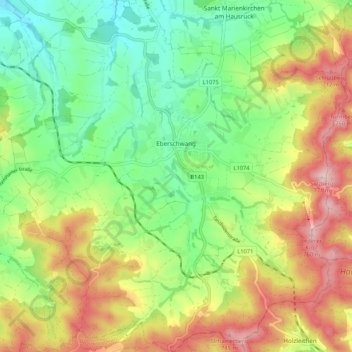
Name: Eberschwang topographic map, elevation, terrain.

Location: Eberschwang, Bezirk Ried im Innkreis, 4906, Austria (48.11393 13.51243 48.18438 13.61330)

Average elevation: 588 m

Minimum elevation: 464 m

Maximum elevation: 765 m

Other topographic maps

Click on a map to view its topography, its elevation and its terrain.

Lerz

Austria > Bezirk Ried im Innkreis > Waldzell

Average elevation: 612 m

Gear up for your next adventure:

🥾Approach Boots - Comfortable boots for hiking and climbing approaches
🥾Trekking Poles - Adjustable trekking poles to reduce knee stress and improve stability
🩹Compact First Aid Kit - Pre-packed essentials for common trail injuries
🕯️Camping Lantern - Illuminates your entire campsite with high-efficiency LEDs
🦟Insect Repellent - Keep mosquitoes and black flies away in wooded areas

As an Amazon Associate, this site earns from qualifying purchases at no extra cost to you.