Geolocate

Guánica topographic map

Click on the map to display elevation.

About this map

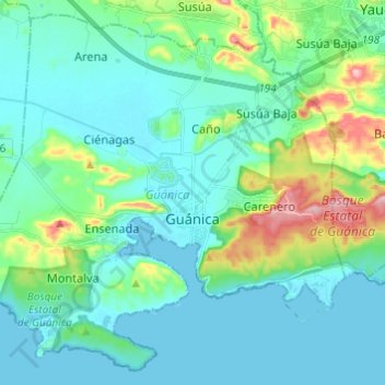
Name: Guánica topographic map, elevation, terrain.

Location: Guánica, Puerto Rico, United States (17.92690 -66.98100 18.03375 -66.85952)

Average elevation: 42 m

Minimum elevation: -1 m

Maximum elevation: 213 m

Other topographic maps

Click on a map to view its topography, its elevation and its terrain.

Toa Alta

United States > Puerto Rico > Toa Alta > Toa Alta

Average elevation: 60 m

Gear up for your next adventure:

🪜Heavy Duty Carabiners - Multi-use clips for securing gear to your backpack
🥾Light Hiking Boots - Lightweight and comfortable boots for day hikes
🥾Approach Boots - Comfortable boots for hiking and climbing approaches
🛏️Camping Sleeping Mat - Comfortable mats for sleeping outdoors
🐕Hiking Dog Pack - Let your canine companion carry their own water and food

As an Amazon Associate, this site earns from qualifying purchases at no extra cost to you.