Geolocate

Bovey topographic map

Click on the map to display elevation.

About this map

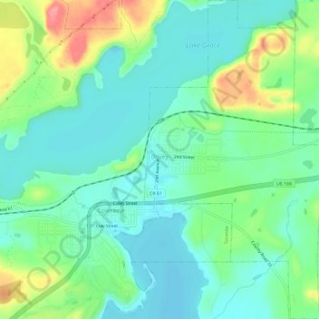
Name: Bovey topographic map, elevation, terrain.

Location: Bovey, Itasca County, Minnesota, United States (47.27536 -93.42170 47.31485 -93.38912)

Average elevation: 417 m

Minimum elevation: 390 m

Maximum elevation: 482 m

Other topographic maps

Click on a map to view its topography, its elevation and its terrain.

Upper Twin Lakes

United States > Minnesota > Itasca County > Rosy

Average elevation: 409 m

Togo

United States > Minnesota > Itasca County

Average elevation: 408 m

Candy Lake

United States > Minnesota > Itasca County

Average elevation: 421 m

Gear up for your next adventure:

🦶Anti-Blister Balm - Prevents friction and hotspots during long ascents
🥾Lightweight Hiking Shoes - Comfortable shoes for day hikes
🔦LED Flashlight - Powerful and long-lasting flashlight for camping and emergencies
🧴Insect Repellent - Protect yourself from bugs during outdoor adventures
🦌Outdoor Trail Camera - Monitor wildlife activity near your favorite spots

As an Amazon Associate, this site earns from qualifying purchases at no extra cost to you.