Geolocate

Lungern topographic map

Click on the map to display elevation.

About this map

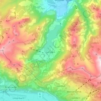
Name: Lungern topographic map, elevation, terrain.

Location: Lungern, Obwalden, 6078, Switzerland (46.75484 8.08988 46.81962 8.23907)

Average elevation: 1,251 m

Minimum elevation: 482 m

Maximum elevation: 2,346 m

Other topographic maps

Click on a map to view its topography, its elevation and its terrain.

Mörlialp

Switzerland > Obwalden > Giswil

Average elevation: 1,376 m

Lüssli

Switzerland > Obwalden > Engelberg

Average elevation: 1,311 m

Alpnachstad

Switzerland > Obwalden > Alpnach

Average elevation: 765 m

Gear up for your next adventure:

🥾Mountain Hiking Boots - High-traction boots for rocky terrain
🧢Sun Hat - Wide-brim hat for sun protection
🚑Survival Whistle - Signal for help across long distances in mountains
🗺️Topographic Maps - Detailed maps to explore trails, mountains, and wilderness areas
🧥Waterproof Hiking Jacket - Protect yourself from rain and wind while hiking

As an Amazon Associate, this site earns from qualifying purchases at no extra cost to you.