Geolocate

Boy Lake topographic map

Click on the map to display elevation.

About this map

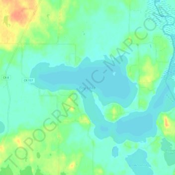
Name: Boy Lake topographic map, elevation, terrain.

Location: Boy Lake, Cass County, Minnesota, United States (47.08411 -94.19875 47.13074 -94.09230)

Average elevation: 400 m

Minimum elevation: 391 m

Maximum elevation: 426 m

Other topographic maps

Click on a map to view its topography, its elevation and its terrain.

Whipholt

United States > Minnesota > Cass County

Average elevation: 403 m

Lake May

United States > Minnesota > Cass County > Walker

Average elevation: 419 m

Kego Lake

United States > Minnesota > Cass County

Average elevation: 413 m

Inguadona

United States > Minnesota > Cass County

Average elevation: 404 m

Hiram Lake

United States > Minnesota > Cass County

Average elevation: 421 m

Gould Lake

United States > Minnesota > Cass County

Average elevation: 399 m

Crooked Lake

United States > Minnesota > Cass County > Wabedo

Average elevation: 406 m

Big Deep Lake

United States > Minnesota > Cass County

Average elevation: 420 m

Snowshoe Lake

United States > Minnesota > Cass County

Average elevation: 406 m

Corset Lake

United States > Minnesota > Cass County

Average elevation: 407 m

Blind Lake

United States > Minnesota > Cass County

Average elevation: 421 m

High Bank Lake

United States > Minnesota > Cass County

Average elevation: 425 m

Gear up for your next adventure:

🥾Hiking Shoes - Durable and comfortable shoes for trail hiking
🥾Mountain Trail Shoes - High-traction shoes for mountain trails
🥾Trail Hiking Socks - Comfortable socks to prevent blisters and fatigue
🧦Crew Hiking Socks - Comfortable socks for long-distance hikes
🧊Portable Cooler - Keep food and drinks cold during outdoor adventures

As an Amazon Associate, this site earns from qualifying purchases at no extra cost to you.