Geolocate

Georgetown topographic map

Interactive map

Click on the map to display elevation.

About this map

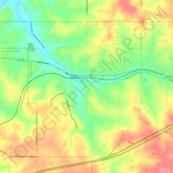
Name: Georgetown topographic map, elevation, terrain.

Location: Georgetown, Floyd County, Indiana, 47122, United States (38.27471 -85.99533 38.30840 -85.93648)

Average elevation: 248 m

Minimum elevation: 198 m

Maximum elevation: 296 m

Other topographic maps

Click on a map to view its topography, its elevation and its terrain.

Floyds Knobs

United States > Indiana > Floyd County

Floyds Knobs, Floyd County, Indiana, 47146, United States

Average elevation: 251 m

Greenville

United States > Indiana > Floyd County

Greenville, Floyd County, Indiana, 47124, United States

Average elevation: 245 m

Galena

United States > Indiana > Floyd County

Galena, Floyd County, Indiana, United States

Average elevation: 232 m

New Albany

United States > Indiana > Floyd County

New Albany, Floyd County, Indiana, 47150, United States

Average elevation: 180 m

Silver Hills

United States > Indiana > Floyd County > New Albany

Silver Hills, New Albany, Floyd County, Indiana, 47150, United States

Average elevation: 160 m

Edwardsville

United States > Indiana > Floyd County

Edwardsville, Floyd County, Indiana, United States

Average elevation: 249 m