Geolocate

Duncan topographic map

Click on the map to display elevation.

About this map

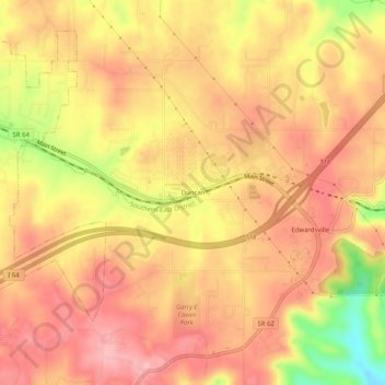
Name: Duncan topographic map, elevation, terrain.

Location: Duncan, Floyd County, Indiana, 47122, United States (38.26812 -85.94497 38.30812 -85.90497)

Average elevation: 260 m

Minimum elevation: 166 m

Maximum elevation: 306 m

Other topographic maps

Click on a map to view its topography, its elevation and its terrain.

Georgetown

United States > Indiana > Floyd County

Average elevation: 248 m

New Albany

United States > Indiana > Floyd County

Average elevation: 180 m

New Albany

United States > Indiana > Floyd County

Average elevation: 180 m

New Albany

United States > Indiana > Floyd County

Average elevation: 180 m

Georgetown

United States > Indiana > Floyd County

Average elevation: 248 m

Gear up for your next adventure:

🧥Packable Rain Jacket - Breathable waterproof layer for unpredictable weather
❄️Traction Ice Cleats - Slip-on spikes for icy trails and winter hiking
🧥Waterproof Hiking Jacket - Protect yourself from rain and wind while hiking
🧭Orienteering Kit - Tools for map reading and navigation in the wild
Lightweight Backpacking Tent - Compact tent for efficient hiking trips

As an Amazon Associate, this site earns from qualifying purchases at no extra cost to you.