Geolocate

Hachijojima topographic map

Click on the map to display elevation.

About this map

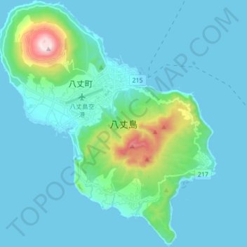
Name: Hachijojima topographic map, elevation, terrain.

Location: Hachijojima, Tokyo, Japan (33.04534 139.73832 33.15965 139.85948)

Average elevation: 97 m

Minimum elevation: 0 m

Maximum elevation: 853 m

Other topographic maps

Click on a map to view its topography, its elevation and its terrain.

Mount Takao

Japan > Tokyo

Average elevation: 399 m

Mount Takao

Japan > Tokyo

Average elevation: 399 m

Iō Island

Japan > Tokyo

Average elevation: 27 m

Iō Island

Japan > Tokyo

Average elevation: 27 m

Iō Island

Japan > Tokyo

Average elevation: 27 m

Tokyo International Airport

Japan > Tokyo

Average elevation: 2 m

Mount Atago

Japan > Tokyo

Average elevation: 60 m

Mount Nokogiri

Japan > Tokyo

Average elevation: 836 m

Gear up for your next adventure:

💧Hydration Pack - Hands-free hydration system for long hikes
👟Leg Gaiters - Keep debris, mud, and snow out of your boots
🧣Merino Neck Gaiter - Protects against wind, sun, and cold at high altitudes
🔪Outdoor Multitool - Versatile tool for repairs and food prep in the wild
🧴Waterproofing Spray - Restore the DWR coating on jackets and tents

As an Amazon Associate, this site earns from qualifying purchases at no extra cost to you.