
Make a donation
Gear up for your next adventure:
As an Amazon Associate, this site earns from qualifying purchases at no extra cost to you.
Catamayo topographic map
Click on the map to display elevation.
Make a donation
Gear up for your next adventure:
As an Amazon Associate, this site earns from qualifying purchases at no extra cost to you.
Catamayo
El clima esta definido por la altitud, siendo las zonas secas las más cálidas.
Make a donation
Gear up for your next adventure:
As an Amazon Associate, this site earns from qualifying purchases at no extra cost to you.
About this map
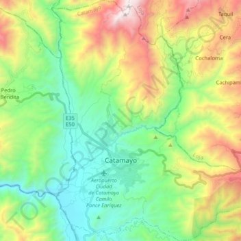
Name: Catamayo topographic map, elevation, terrain.
Location: Catamayo, Loja, 110301, Ecuador (-4.03970 -79.40279 -3.88233 -79.26203)
Average elevation: 1,747 m
Minimum elevation: 1,103 m
Maximum elevation: 3,010 m
Make a donation
Gear up for your next adventure:
As an Amazon Associate, this site earns from qualifying purchases at no extra cost to you.
Other topographic maps
Click on a map to view its topography, its elevation and its terrain.