Geolocate

Caprarola topographic map

Click on the map to display elevation.

About this map

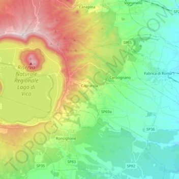
Name: Caprarola topographic map, elevation, terrain.

Location: Caprarola, Viterbo, Lazio, 01032, Italy (42.28261 12.13138 42.36487 12.29836)

Average elevation: 453 m

Minimum elevation: 227 m

Maximum elevation: 901 m

Other topographic maps

Click on a map to view its topography, its elevation and its terrain.

Monte Raschio

Italy > Lazio > Viterbo > Oriolo Romano

Average elevation: 448 m

Bagnaia

Italy > Lazio > Viterbo > Viterbo

Average elevation: 464 m

Isola Bisentina

Italy > Lazio > Viterbo > Capodimonte

Average elevation: 304 m

Cura

Italy > Lazio > Viterbo > Vetralla

Average elevation: 393 m

Gear up for your next adventure:

🛏️Camping Sleeping Mat - Comfortable mats for sleeping outdoors
🧴Insect Repellent - Protect yourself from bugs during outdoor adventures
🍽️Titanium Camping Spork - Ultralight and indestructible eating utensil
🥘Camping Cookware Set - Compact nesting pots and pans for trail cooking
🧦Thermal Socks - Warm socks for winter hiking or camping

As an Amazon Associate, this site earns from qualifying purchases at no extra cost to you.