Geolocate

Broadhembury topographic map

Click on the map to display elevation.

About this map

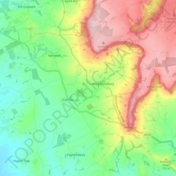
Name: Broadhembury topographic map, elevation, terrain.

Location: Broadhembury, East Devon, Devon, England, United Kingdom (50.81029 -3.34879 50.85753 -3.24072)

Average elevation: 151 m

Minimum elevation: 51 m

Maximum elevation: 294 m

Gear up for your next adventure:

🎒Hiking Daypack - Lightweight and durable backpacks for day trips and excursions
🛌Down Sleeping Bag - Superior warmth-to-weight ratio for cold nights
🥾Waterproof Hiking Boots - Boots keeping your feet dry in wet conditions
🥫Freeze-Dried Meals - Lightweight, high-calorie nutrition for multi-day treks
🥾Trail Running Shoes - Lightweight and durable shoes for trail running

As an Amazon Associate, this site earns from qualifying purchases at no extra cost to you.