
Hilderstone topographic map
Click on the map to display elevation.
About this map
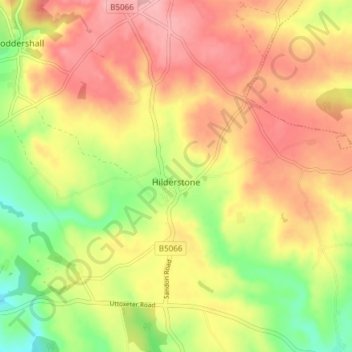
Name: Hilderstone topographic map, elevation, terrain.
Location: Hilderstone, Stafford, Staffordshire, England, United Kingdom (52.89538 -2.10813 52.92900 -2.03297)
Average elevation: 188 m
Minimum elevation: 118 m
Maximum elevation: 244 m
Other topographic maps
Click on a map to view its topography, its elevation and its terrain.
Knightley
United Kingdom > England > Staffordshire > Stafford > Gnosall > Knightley
Average elevation: 127 m
Drointon
United Kingdom > England > Staffordshire > Stafford > Stowe-by-Chartley
Average elevation: 110 m