
Make a donation
Gear up for your next adventure:
As an Amazon Associate, this site earns from qualifying purchases at no extra cost to you.
Zadar topographic map
Click on the map to display elevation.
Make a donation
Gear up for your next adventure:
As an Amazon Associate, this site earns from qualifying purchases at no extra cost to you.
Zadar
Since records began in 1961, the highest temperature recorded at the local weather station at an elevation of 5 metres (16 ft) was 36.3 °C (97.3 °F), on 4 August 2017. The coldest temperature was −9.1 °C (15.6 °F), on 23 January 1963.
Make a donation
Gear up for your next adventure:
As an Amazon Associate, this site earns from qualifying purchases at no extra cost to you.
About this map
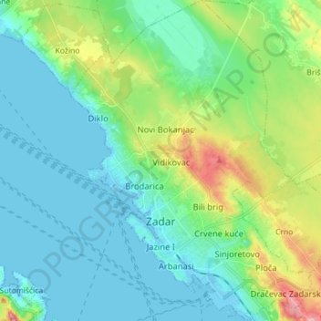
Name: Zadar topographic map, elevation, terrain.
Location: Zadar, Grad Zadar, Zadar County, Croatia (44.08510 15.19560 44.18704 15.30222)
Average elevation: 29 m
Minimum elevation: -3 m
Maximum elevation: 123 m
Make a donation
Gear up for your next adventure:
As an Amazon Associate, this site earns from qualifying purchases at no extra cost to you.
Other topographic maps
Click on a map to view its topography, its elevation and its terrain.
Bijela
Croatia > Zadar County > Grad Obrovac > Gornji Karin
Bijela is one of the smallest rivers in northern Dalmatia, flowing from east to west, and enters Karin Sea at Gornji Karin, a village belonging to the Town of Obrovac in the Zadar County. The spring of Bijela is located at an altitude of approximately 300 meters, below the Pržun mountain peak (351 meters…
Average elevation: 87 m
Make a donation
Gear up for your next adventure:
As an Amazon Associate, this site earns from qualifying purchases at no extra cost to you.
Make a donation
Gear up for your next adventure:
As an Amazon Associate, this site earns from qualifying purchases at no extra cost to you.
Make a donation
Gear up for your next adventure:
As an Amazon Associate, this site earns from qualifying purchases at no extra cost to you.
Make a donation
Gear up for your next adventure:
As an Amazon Associate, this site earns from qualifying purchases at no extra cost to you.