Geolocate

Capinota topographic map

Click on the map to display elevation.

About this map

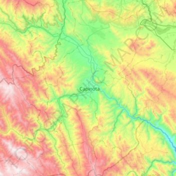
Name: Capinota topographic map, elevation, terrain.

Location: Capinota, Cochabamba, Bolivia (-17.95172 -66.39383 -17.47259 -66.10737)

Average elevation: 3,069 m

Minimum elevation: 2,187 m

Maximum elevation: 4,442 m

Other topographic maps

Click on a map to view its topography, its elevation and its terrain.

Cochabamba

Bolivia > Cochabamba > Cercado > Cochabamba

Average elevation: 3,145 m

Gear up for your next adventure:

🦶Anti-Blister Balm - Prevents friction and hotspots during long ascents
💧Reusable Water Bottle - Durable water bottles for hydration on trails
🚲MTB Frame Bag - Carry tools and maps directly on your bicycle frame
Lightweight Backpacking Tent - Compact tent for efficient hiking trips
🛌Down Sleeping Bag - Superior warmth-to-weight ratio for cold nights

As an Amazon Associate, this site earns from qualifying purchases at no extra cost to you.