Geolocate

Colorado City topographic map

Click on the map to display elevation.

About this map

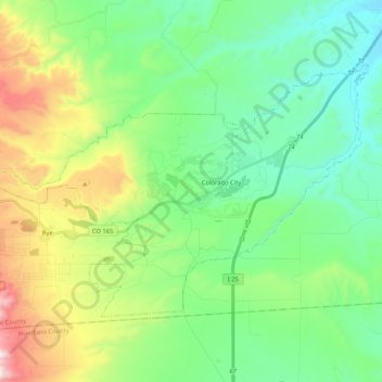
Name: Colorado City topographic map, elevation, terrain.

Location: Colorado City, Pueblo County, Colorado, 81019, United States (37.88732 -104.96318 37.99585 -104.75477)

Average elevation: 1,901 m

Minimum elevation: 1,636 m

Maximum elevation: 2,555 m

Other topographic maps

Click on a map to view its topography, its elevation and its terrain.

Pueblo West

United States > Colorado > Pueblo County

Average elevation: 1,543 m

Beulah

United States > Colorado > Pueblo County

Average elevation: 2,013 m

Eden

United States > Colorado > Pueblo County > Pueblo

Average elevation: 1,472 m

Rye

United States > Colorado > Pueblo County

Rye has a subtropical highland climate (Köppen Cfb), a climate type usually associated with maritime regions, but is also found in high elevation areas in which summer temperatures are moderated by altitude. Precipitation exceeds that of semi-arid places, and average winter temperatures exceed freezing (O°C,…

Average elevation: 2,090 m

Beulah

United States > Colorado > Pueblo County

Average elevation: 2,013 m

Pueblo

United States > Colorado > Pueblo County > Pueblo

Average elevation: 1,509 m

Gear up for your next adventure:

🛏️Sleeping Bag - Warm and compact sleeping bags for outdoor camping
💡Solar Camping Lamp - Eco-friendly lighting for campsites
🔥Emergency Fire Starter - Reliable ignition source for all weather conditions
🚲Heavy Duty Bike Lock - Secure your bike at the trailhead or during stops
🥾Trail Running Boots - Durable shoes designed for trail running

As an Amazon Associate, this site earns from qualifying purchases at no extra cost to you.