Geolocate

Beulah topographic map

Click on the map to display elevation.

About this map

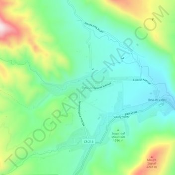
Name: Beulah topographic map, elevation, terrain.

Location: Beulah, Pueblo County, Colorado, 81023, United States (38.05501 -105.00666 38.09501 -104.96666)

Average elevation: 2,013 m

Minimum elevation: 1,877 m

Maximum elevation: 2,326 m

Gear up for your next adventure:

🧢Outdoor Cap - Protective cap for sun and rain during hikes
🔥Emergency Fire Starter - Reliable ignition source for all weather conditions
🧤Insulated Winter Gloves - Heavy-duty protection for sub-zero Canadian adventures
🌬️Windproof Camp Stove - Efficient cooking even on exposed mountain peaks
🧥Softshell Jacket - Windproof and breathable jacket for hiking

As an Amazon Associate, this site earns from qualifying purchases at no extra cost to you.