Geolocate

Catlett topographic map

Click on the map to display elevation.

About this map

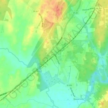
Name: Catlett topographic map, elevation, terrain.

Location: Catlett, Fauquier County, Virginia, 20119, United States (38.63373 -77.66055 38.67373 -77.62055)

Average elevation: 80 m

Minimum elevation: 59 m

Maximum elevation: 108 m

Other topographic maps

Click on a map to view its topography, its elevation and its terrain.

Bealeton

United States > Virginia > Fauquier County > Bealeton

Average elevation: 100 m

New Baltimore

United States > Virginia > Fauquier County

Average elevation: 148 m

Rectortown

United States > Virginia > Fauquier County

Average elevation: 161 m

Upperville

United States > Virginia > Fauquier County

Average elevation: 172 m

Broad Run

United States > Virginia > Fauquier County > Broad Run

Average elevation: 164 m

Gear up for your next adventure:

🌬️Windproof Camp Stove - Efficient cooking even on exposed mountain peaks
Camping Coffee Maker - Brew fresh coffee anywhere on the topographic map
🛌Down Sleeping Bag - Superior warmth-to-weight ratio for cold nights
🥾Trekking Boots - Durable boots for long-distance trekking
🚲MTB Frame Bag - Carry tools and maps directly on your bicycle frame

As an Amazon Associate, this site earns from qualifying purchases at no extra cost to you.