Geolocate

Mocoa topographic map

Click on the map to display elevation.

About this map

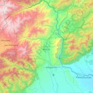
Name: Mocoa topographic map, elevation, terrain.

Location: Mocoa, Putumayo, RAP Amazonía, 860001, Colombia (0.86467 -76.92246 1.46782 -76.40942)

Average elevation: 1,414 m

Minimum elevation: 251 m

Maximum elevation: 3,909 m

Other topographic maps

Click on a map to view its topography, its elevation and its terrain.

Cerro Patascoy

Colombia > Putumayo > Orito

Average elevation: 3,475 m

Puerto Guzmán

Colombia > Putumayo > Puerto Guzmán

Average elevation: 272 m

Puerto Guzmán

Colombia > Putumayo > Puerto Guzmán

Average elevation: 272 m

Mecaya

Colombia > Putumayo > Puerto Leguízamo

Average elevation: 189 m

Sibundoy

Colombia > Putumayo > Sibundoy > Sibundoy

Average elevation: 2,302 m

Cerro Patascoy

Colombia > Putumayo > Orito

Average elevation: 3,468 m

Gear up for your next adventure:

👟Trail Running Shoes - Agile footwear for fast-paced topographic exploration
🥾Trail Hiking Boots - Supportive boots for rough trails
🛶Kayak Dry Bag - Waterproof storage for kayaking adventures
Backpacking Tent - Lightweight tent for long-distance hiking trips
🥾All-Terrain Hiking Boots - Versatile boots for varied hiking conditions

As an Amazon Associate, this site earns from qualifying purchases at no extra cost to you.