
Balboa Park topographic map
Click on the map to display elevation.
About this map
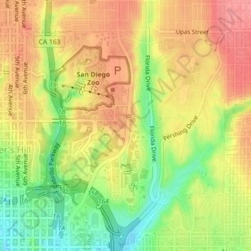
Name: Balboa Park topographic map, elevation, terrain.
Average elevation: 71 m
Minimum elevation: 23 m
Maximum elevation: 107 m
Other topographic maps
Click on a map to view its topography, its elevation and its terrain.
Mission Trails Regional Park
United States > California > San Diego County > San Diego
Average elevation: 154 m
Valencia Park
United States > California > San Diego County > San Diego > Valencia Park
Average elevation: 56 m
San Diego
United States > California > San Diego County > San Diego
The climate in San Diego, like most of Southern California, often varies significantly over short geographical distances, resulting in microclimates. In San Diego, this is mostly because of the city's topography (the Bay, and the numerous hills, mountains, and canyons). Frequently, particularly during the "May…
Average elevation: 57 m
Alta Vista
United States > California > San Diego County > San Diego > Alta Vista
Average elevation: 81 m
South Encanto
United States > California > San Diego County > San Diego > South Encanto
Average elevation: 80 m
Colina Park
United States > California > San Diego County > San Diego > Colina Park
Average elevation: 110 m