
Gore topographic map
Click on the map to display elevation.
About this map
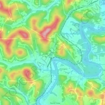
Name: Gore topographic map, elevation, terrain.
Location: Gore, Harrison County, West Virginia, 26369, United States (39.29467 -80.37224 39.33467 -80.33224)
Average elevation: 339 m
Minimum elevation: 275 m
Maximum elevation: 465 m
Other topographic maps
Click on a map to view its topography, its elevation and its terrain.
Clarksburg
United States > West Virginia > Harrison County
Clarksburg had a humid continental climate if one considers the 0 °C isotherm. The latest temperature numbers have the climate as humid subtropical (Cfa). To the molds of Köppen the climate may be considered the southern boundary of the Dfb zone at low altitudes in the North American continent (limit of 39…
Average elevation: 347 m
Clarksburg
United States > West Virginia > Harrison County
Clarksburg is located at the junction of U.S. 50 and U.S. 19, two miles west of the junction of U.S. 50 with Interstate 79. The city lies at an elevation of 1,007 feet at the junction of Elk Creek and the West Fork River of the Monongahela River.
Average elevation: 347 m
Clarksburg City Park
United States > West Virginia > Harrison County > Nutter Fort
Average elevation: 335 m