Geolocate

Bridgeport topographic map

Click on the map to display elevation.

About this map

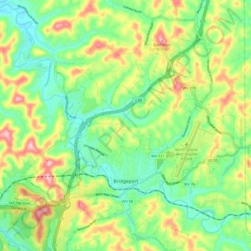
Name: Bridgeport topographic map, elevation, terrain.

Location: Bridgeport, Harrison County, West Virginia, 26330, United States (39.26162 -80.28411 39.35058 -80.20230)

Average elevation: 352 m

Minimum elevation: 277 m

Maximum elevation: 475 m

Other topographic maps

Click on a map to view its topography, its elevation and its terrain.

Goodhope

United States > West Virginia > Harrison County

Average elevation: 337 m

Wyatt

United States > West Virginia > Harrison County

Average elevation: 356 m

Gore

United States > West Virginia > Harrison County

Average elevation: 339 m

Haywood

United States > West Virginia > Harrison County

Average elevation: 328 m

Viropa

United States > West Virginia > Harrison County

Average elevation: 333 m

Gear up for your next adventure:

🚲Handlebar Phone Mount - View topographic-map.com live while cycling
👟Trail Running Shoes - Agile footwear for fast-paced topographic exploration
🌬️Windproof Camp Stove - Efficient cooking even on exposed mountain peaks
🕶️Polarized Sunglasses - Protect your eyes with durable polarized lenses
🧭GPS Tracker - Track your location in remote areas safely

As an Amazon Associate, this site earns from qualifying purchases at no extra cost to you.