Geolocate

Adlington topographic map

Click on the map to display elevation.

About this map

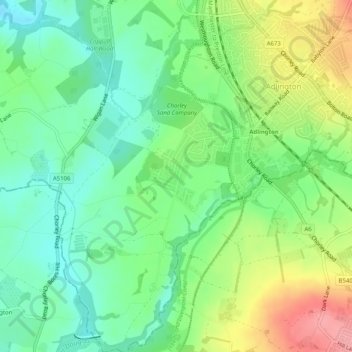
Name: Adlington topographic map, elevation, terrain.

Location: Adlington, Chorley, Lancashire, England, United Kingdom (53.59359 -2.63220 53.62358 -2.59096)

Average elevation: 95 m

Minimum elevation: 56 m

Maximum elevation: 162 m

Gear up for your next adventure:

🎒Backpack Rain Cover - External shield to keep your entire pack dry
🧢Hiking Sun Hat - Wide-brimmed protection for exposed mountain ridges
🔦LED Headtorch - Bright and durable light for night activities
🐕Hiking Dog Pack - Let your canine companion carry their own water and food
🕯️Camping Lantern - Illuminates your entire campsite with high-efficiency LEDs

As an Amazon Associate, this site earns from qualifying purchases at no extra cost to you.