
Make a donation
Gear up for your next adventure:
As an Amazon Associate, this site earns from qualifying purchases at no extra cost to you.
La Tremblade topographic map
Click on the map to display elevation.
Make a donation
Gear up for your next adventure:
As an Amazon Associate, this site earns from qualifying purchases at no extra cost to you.
About this map
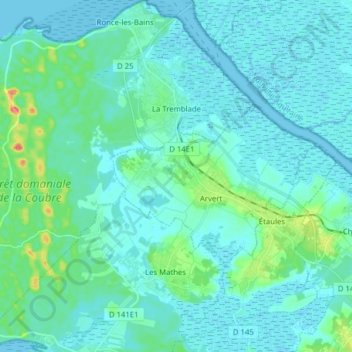
Name: La Tremblade topographic map, elevation, terrain.
Average elevation: 8 m
Minimum elevation: -2 m
Maximum elevation: 52 m
Make a donation
Gear up for your next adventure:
As an Amazon Associate, this site earns from qualifying purchases at no extra cost to you.
Other topographic maps
Click on a map to view its topography, its elevation and its terrain.
Phare de la Coubre
France > Nouvelle-Aquitaine > Charente-Maritime > La Tremblade
Average elevation: 3 m
Château de Bonnemie
France > Nouvelle-Aquitaine > Charente-Maritime > Saint-Pierre-d'Oléron > Dame Grand
Average elevation: 7 m
Make a donation
Gear up for your next adventure:
As an Amazon Associate, this site earns from qualifying purchases at no extra cost to you.
Maine Gaudin
France > Nouvelle-Aquitaine > Charente-Maritime > Saint-Palais-sur-Mer
Average elevation: 14 m
Le Terrier des Mouches
France > Nouvelle-Aquitaine > Charente-Maritime > Saintes
Average elevation: 39 m
Make a donation
Gear up for your next adventure:
As an Amazon Associate, this site earns from qualifying purchases at no extra cost to you.
Saint-Maixent
France > Nouvelle-Aquitaine > Charente-Maritime > Fontaine-Chalendray
Average elevation: 103 m
Make a donation
Gear up for your next adventure:
As an Amazon Associate, this site earns from qualifying purchases at no extra cost to you.
Chez Pelaud
France > Nouvelle-Aquitaine > Charente-Maritime > Saint-Germain-de-Lusignan
Average elevation: 58 m
La Biroire
France > Nouvelle-Aquitaine > Charente-Maritime > Saint-Pierre-d'Oléron
Average elevation: 3 m
Make a donation
Gear up for your next adventure:
As an Amazon Associate, this site earns from qualifying purchases at no extra cost to you.
Hameau des Quatre Moulins
France > Nouvelle-Aquitaine > Charente-Maritime > Tesson
Average elevation: 47 m
Les Nauds
France > Nouvelle-Aquitaine > Charente-Maritime > Saint-Bris-des-Bois
Average elevation: 73 m
Maine-Bertrand
France > Nouvelle-Aquitaine > Charente-Maritime > Saint-Palais-sur-Mer
Average elevation: 18 m
Make a donation
Gear up for your next adventure:
As an Amazon Associate, this site earns from qualifying purchases at no extra cost to you.
Le Pont de Sablonceaux
France > Nouvelle-Aquitaine > Charente-Maritime > Sablonceaux > Saint-André-de-Sablonceaux
Average elevation: 22 m
Moulin de la Croix
France > Nouvelle-Aquitaine > Charente-Maritime > Saint-Pierre-d'Oléron
Average elevation: 6 m
Make a donation
Gear up for your next adventure:
As an Amazon Associate, this site earns from qualifying purchases at no extra cost to you.
Les Biraudes
France > Nouvelle-Aquitaine > Charente-Maritime > Saint-Martin-de-Ré
Average elevation: 7 m
Make a donation
Gear up for your next adventure:
As an Amazon Associate, this site earns from qualifying purchases at no extra cost to you.
Le Breuil Malmaud
France > Nouvelle-Aquitaine > Charente-Maritime > Saint-Martin-de-Juillers
Average elevation: 65 m
Make a donation
Gear up for your next adventure:
As an Amazon Associate, this site earns from qualifying purchases at no extra cost to you.
Les Pibles
France > Nouvelle-Aquitaine > Charente-Maritime > Saint-Pierre-d'Oléron
Average elevation: 3 m
Les Landes
France > Nouvelle-Aquitaine > Charente-Maritime > La Chapelle-des-Pots
Average elevation: 65 m
Make a donation
Gear up for your next adventure:
As an Amazon Associate, this site earns from qualifying purchases at no extra cost to you.
Moulin de Fief Melin
France > Nouvelle-Aquitaine > Charente-Maritime > La Gaconnière
Average elevation: 3 m
Make a donation
Gear up for your next adventure:
As an Amazon Associate, this site earns from qualifying purchases at no extra cost to you.
Le Caillaud
France > Nouvelle-Aquitaine > Charente-Maritime > Talmont-sur-Gironde
Average elevation: 3 m
Make a donation
Gear up for your next adventure:
As an Amazon Associate, this site earns from qualifying purchases at no extra cost to you.
Grand-Village
France > Nouvelle-Aquitaine > Charente-Maritime > Le Grand-Village-Plage
Average elevation: 4 m
Vergeroux
France > Nouvelle-Aquitaine > Charente-Maritime > Vergeroux > Vergeroux
Average elevation: 5 m
Le Jadeau
France > Nouvelle-Aquitaine > Charente-Maritime > Chaillevette > Maine-Auriou > Le Jadeau
Average elevation: 8 m
Tonnay-Boutonne
France > Nouvelle-Aquitaine > Charente-Maritime > Tonnay-Boutonne > Tonnay-Boutonne
Average elevation: 13 m
Make a donation
Gear up for your next adventure:
As an Amazon Associate, this site earns from qualifying purchases at no extra cost to you.
Salles-sur-Mer
France > Nouvelle-Aquitaine > Charente-Maritime > Salles-sur-Mer > Salles-sur-Mer
Average elevation: 10 m
Moulin Brun
France > Nouvelle-Aquitaine > Charente-Maritime > Saint-Julien-de-l'Escap
Average elevation: 28 m
Port-d'Envaux
France > Nouvelle-Aquitaine > Charente-Maritime > Port-d'Envaux > Port-d'Envaux
Average elevation: 17 m
Make a donation
Gear up for your next adventure:
As an Amazon Associate, this site earns from qualifying purchases at no extra cost to you.
Abbaye de Fontdouce
France > Nouvelle-Aquitaine > Charente-Maritime > Saint-Bris-des-Bois
Average elevation: 78 m
Make a donation
Gear up for your next adventure:
As an Amazon Associate, this site earns from qualifying purchases at no extra cost to you.
La Combe
France > Nouvelle-Aquitaine > Charente-Maritime > Surgères > Surgères
Average elevation: 40 m
Chez Belineau
France > Nouvelle-Aquitaine > Charente-Maritime > Saint-Thomas-de-Conac
Average elevation: 19 m
L'Ormeau
France > Nouvelle-Aquitaine > Charente-Maritime > La Gripperie-Saint-Symphorien
Average elevation: 19 m
Make a donation
Gear up for your next adventure:
As an Amazon Associate, this site earns from qualifying purchases at no extra cost to you.
Make a donation
Gear up for your next adventure:
As an Amazon Associate, this site earns from qualifying purchases at no extra cost to you.
Make a donation
Gear up for your next adventure:
As an Amazon Associate, this site earns from qualifying purchases at no extra cost to you.
Chassit
France > Nouvelle-Aquitaine > Charente-Maritime > Saint-Palais-de-Négrignac
Average elevation: 88 m
Godechaud
France > Nouvelle-Aquitaine > Charente-Maritime > Aytré > La Lizardière
Average elevation: 4 m
Make a donation
Gear up for your next adventure:
As an Amazon Associate, this site earns from qualifying purchases at no extra cost to you.
La Sauzaie
France > Nouvelle-Aquitaine > Charente-Maritime > Mortagne-sur-Gironde
Average elevation: 38 m
Le Buisson
France > Nouvelle-Aquitaine > Charente-Maritime > Salignac-sur-Charente
Average elevation: 15 m
Make a donation
Gear up for your next adventure:
As an Amazon Associate, this site earns from qualifying purchases at no extra cost to you.
La Pree aux Boeufs
France > Nouvelle-Aquitaine > Charente-Maritime > Nieul-sur-Mer
Average elevation: 6 m
Make a donation
Gear up for your next adventure:
As an Amazon Associate, this site earns from qualifying purchases at no extra cost to you.
La Barre
France > Nouvelle-Aquitaine > Charente-Maritime > Gémozac > Louzignac
Average elevation: 43 m
Le Lindron
France > Nouvelle-Aquitaine > Charente-Maritime > Marennes-Hiers-Brouage
Average elevation: 5 m
Les Boucholeurs
France > Nouvelle-Aquitaine > Charente-Maritime > Châtelaillon-Plage
Average elevation: 1 m
La Grande Voine
France > Nouvelle-Aquitaine > Charente-Maritime > La Vallée > Les Grands-Maisons
Average elevation: 4 m
Make a donation
Gear up for your next adventure:
As an Amazon Associate, this site earns from qualifying purchases at no extra cost to you.
Les Ridelleries
France > Nouvelle-Aquitaine > Charente-Maritime > Corme-Écluse
Average elevation: 19 m
Pointe de Chassiron
France > Nouvelle-Aquitaine > Charente-Maritime > Saint-Denis-d'Oléron > Chassiron
Average elevation: 2 m
Make a donation
Gear up for your next adventure:
As an Amazon Associate, this site earns from qualifying purchases at no extra cost to you.
Bois Claveau
France > Nouvelle-Aquitaine > Charente-Maritime > Saint-Georges-des-Coteaux
Average elevation: 52 m
Chez Poineau
France > Nouvelle-Aquitaine > Charente-Maritime > Réaux-sur-Trèfle
Average elevation: 61 m
Le Petit Breuil
France > Nouvelle-Aquitaine > Charente-Maritime > Marennes-Hiers-Brouage
Average elevation: 7 m
Make a donation
Gear up for your next adventure:
As an Amazon Associate, this site earns from qualifying purchases at no extra cost to you.
La Renaudrie
France > Nouvelle-Aquitaine > Charente-Maritime > Clion > Clion-sur-Seugne
Average elevation: 34 m
La Boirie
France > Nouvelle-Aquitaine > Charente-Maritime > Saint-Pierre-d'Oléron
Average elevation: 4 m
Make a donation
Gear up for your next adventure:
As an Amazon Associate, this site earns from qualifying purchases at no extra cost to you.
Chez Richard
France > Nouvelle-Aquitaine > Charente-Maritime > Montlieu-la-Garde
Average elevation: 108 m
Les Mazerolles
France > Nouvelle-Aquitaine > Charente-Maritime > Mirambeau > Naudinet
Average elevation: 58 m
Make a donation
Gear up for your next adventure:
As an Amazon Associate, this site earns from qualifying purchases at no extra cost to you.