Geolocate

Caynarachi topographic map

Click on the map to display elevation.

About this map

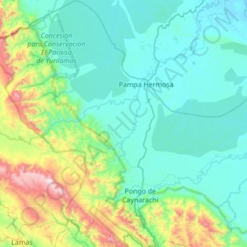
Name: Caynarachi topographic map, elevation, terrain.

Location: Caynarachi, Province of Lamas, San Martín, Peru (-6.43180 -76.54769 -5.95066 -76.12721)

Average elevation: 426 m

Minimum elevation: 129 m

Maximum elevation: 1,840 m

Other topographic maps

Click on a map to view its topography, its elevation and its terrain.

Morro de Calzada

Peru > San Martín > Calzada > Calzada

Average elevation: 961 m

Rey del Valle

Peru > San Martín > Alonso de Alvarado

Average elevation: 1,197 m

Guantanamo

Peru > San Martín

Average elevation: 559 m

San Andrés

Peru > San Martín > Jepelacio

Average elevation: 1,275 m

Gear up for your next adventure:

💡LED Headlamp - Hands-free illumination for night hiking and camping
🐕Hiking Dog Pack - Let your canine companion carry their own water and food
💧Filtered Water Bottle - Safe drinking water on the go
🧥Insulated Jacket - Keep warm in cold outdoor conditions
🪑Insulated Seat Pad - Protect your seat from cold rocks and wet logs

As an Amazon Associate, this site earns from qualifying purchases at no extra cost to you.