
Make a donation
Gear up for your next adventure:
As an Amazon Associate, this site earns from qualifying purchases at no extra cost to you.
Christazhofen topographic map
Click on the map to display elevation.
Make a donation
Gear up for your next adventure:
As an Amazon Associate, this site earns from qualifying purchases at no extra cost to you.
About this map
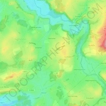
Name: Christazhofen topographic map, elevation, terrain.
Average elevation: 680 m
Minimum elevation: 631 m
Maximum elevation: 759 m
Make a donation
Gear up for your next adventure:
As an Amazon Associate, this site earns from qualifying purchases at no extra cost to you.
Other topographic maps
Click on a map to view its topography, its elevation and its terrain.
Weingarten
Deutschland > Baden-Württemberg > Landkreis Ravensburg
Weingarten liegt unmittelbar nördlich von Ravensburg und nur wenige Kilometer westlich des Altdorfer Walds am Ostrand des Schussenbeckens im mittleren Tal der Schussen, die in den Bodensee fließt und somit ein (rechter) Rhein-Zufluss ist. Die Altstadt, das ehemalige Altdorf, liegt im Tal der Scherzach, einem…
Average elevation: 505 m
Make a donation
Gear up for your next adventure:
As an Amazon Associate, this site earns from qualifying purchases at no extra cost to you.
Aulendorf
Deutschland > Baden-Württemberg > Landkreis Ravensburg
Im Jahr 2009 beschloss der baden-württembergische Ministerrat ein Maßnahmenpaket, das bei gleichzeitigen drastischen Einsparungen der Stadt Aulendorf finanzielle Hilfen in Höhe von 39,2 Millionen Euro bis zum Jahr 2016 vorsah. Aulendorf ist die einzige Stadt in Baden-Württemberg, die finanzielle…
Average elevation: 580 m
Schmiedebach
Deutschland > Baden-Württemberg > Landkreis Ravensburg > Leutkirch im Allgäu > Hünlishofen
Average elevation: 661 m
Make a donation
Gear up for your next adventure:
As an Amazon Associate, this site earns from qualifying purchases at no extra cost to you.
Altshausen
Deutschland > Baden-Württemberg > Landkreis Ravensburg > Altshausen
Altshausen liegt in Oberschwaben, etwa vierzig Kilometer nördlich des Bodensees. Nordwestlich der Gemeinde befindet sich der Naturpark Obere Donau. Südöstlich der Gemeinde befindet sich der Höhenzug Altdorfer Wald.
Average elevation: 589 m