
Thank you for supporting this site ❤️
Make a donation
Make a donation
Gear up for your next adventure:
As an Amazon Associate, this site earns from qualifying purchases at no extra cost to you.
Altshausen topographic map
Click on the map to display elevation.
Thank you for supporting this site ❤️
Make a donation
Make a donation
Gear up for your next adventure:
As an Amazon Associate, this site earns from qualifying purchases at no extra cost to you.
Altshausen
Altshausen liegt in Oberschwaben, etwa vierzig Kilometer nördlich des Bodensees. Nordwestlich der Gemeinde befindet sich der Naturpark Obere Donau. Südöstlich der Gemeinde befindet sich der Höhenzug Altdorfer Wald.
Thank you for supporting this site ❤️
Make a donation
Make a donation
Gear up for your next adventure:
As an Amazon Associate, this site earns from qualifying purchases at no extra cost to you.
About this map
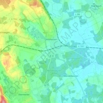
Name: Altshausen topographic map, elevation, terrain.
Average elevation: 589 m
Minimum elevation: 560 m
Maximum elevation: 683 m
Thank you for supporting this site ❤️
Make a donation
Make a donation
Gear up for your next adventure:
As an Amazon Associate, this site earns from qualifying purchases at no extra cost to you.