Geolocate

Vils topographic map

Click on the map to display elevation.

About this map

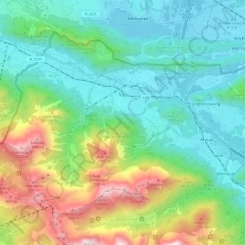
Name: Vils topographic map, elevation, terrain.

Location: Vils, Bezirk Reutte, Tyrol, 6682, Austria (47.51093 10.56109 47.56974 10.67801)

Average elevation: 1,159 m

Minimum elevation: 780 m

Maximum elevation: 2,096 m

Other topographic maps

Click on a map to view its topography, its elevation and its terrain.

Aggenstein

Austria > Tyrol > Bezirk Reutte

Average elevation: 1,478 m

Tannheim Mountains

Austria > Tyrol > Bezirk Reutte > Musau

Average elevation: 1,646 m

Lähn

Austria > Tyrol > Bezirk Reutte

Average elevation: 1,049 m

Hochvogel

Austria > Tyrol > Bezirk Reutte > Hinterhornbach

Average elevation: 1,897 m

Gear up for your next adventure:

🛶Waterproof Dry Bags - Keep electronics and clothes dry during river crossings
🧰Multitool Knife - Compact and versatile tool for outdoor use
🥾Waterproof Trail Shoes - Shoes designed to handle wet terrain
🧤Insulated Winter Gloves - Heavy-duty protection for sub-zero Canadian adventures
🔥Emergency Fire Starter - Reliable ignition source for all weather conditions

As an Amazon Associate, this site earns from qualifying purchases at no extra cost to you.