Geolocate

El Arish topographic map

Click on the map to display elevation.

About this map

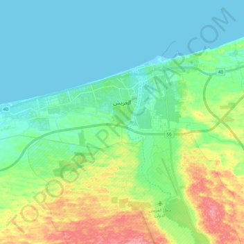
Name: El Arish topographic map, elevation, terrain.

Location: El Arish, North Sinai, Egypt (31.05800 33.67675 31.16168 33.86818)

Average elevation: 29 m

Minimum elevation: -1 m

Maximum elevation: 115 m

Other topographic maps

Click on a map to view its topography, its elevation and its terrain.

Lake Bardawil

Egypt > North Sinai

Average elevation: 37 m

El Hassana

Egypt > North Sinai

Average elevation: 243 m

El Gorah

Egypt > North Sinai

Average elevation: 87 m

Bir al Abd

Egypt > North Sinai

Average elevation: 10 m

Nekhel

Egypt > North Sinai

Nikhel (Arabic: نِخِل ; also spelled and pronounced Nikhl ) is administratively a city (though realistically more of a town) and the capital of the eponymous markaz (county) North Sinai Governorate, Egypt. It is located in the heart of the Sinai Peninsula bordered to its south by the South Sinai…

Average elevation: 439 m

Gear up for your next adventure:

🔭Compact Binoculars - Lightweight optics for scouting trails and wildlife
🦶Hiking Shoe Insoles - Added support for high arches and long days on feet
🧥Ultralight Puffy Jacket - Maximum warmth that packs down to the size of an orange
🥾Trail Running Boots - Durable shoes designed for trail running
🕶️Polarized Sunglasses - Reduces glare from snow and water at high elevations

As an Amazon Associate, this site earns from qualifying purchases at no extra cost to you.